


Nepal, an agrarian country seems pretty laid back when it comes to adopting digital tools in agriculture. Not that, we Nepalese are away from or unacknowledged of cost-effective mechanization or extension services offered by few apt mobile applications. But what besides necessitate are technologies that conform with changing the climatic regime and present soil properties. And, Geographic Information System (GIS) is one of such tools. GIS is a system/technological field that helps to organize, understand, and communicate the geographical objects around us by enabling evidence-based decision support through spatial analysis of datasets.
Conventional farming practices which we have been following for ages treat every parcel of farmland uniformly for application of fertilizer, pesticides, and amendments of soil. Consequently, the constituents of soil are not as same as those used to be before. Each piece of farmland has its features associated with a spatial variation which might make it dissimilar in many ways even with adjacent farms. Besides, there has been a vast change in the requirements of the crop throughout the decades to take a yield of the same quality and quantity. Before we hope to harvest heaps of yield, today it is of utmost need to study, match and document crop necessities and soil characteristics carefully to make farm fuller sustainably. This indicates the need to differentiate the field into site-specific management units using GIS to manage and monitor them according to their properties. GIS in agriculture is not a new phenomenon; albeit, developing countries like Nepal have yet to witness implications and corresponding outcomes of agriculture mapping.
The major concern in Nepalese Agriculture development is the necessity to increase crop productivity, employment opportunities, and economic growth of poor segments of the population that highly rely on farming for daily exigencies. And, agriculture mapping is supposed to address these conditions to a greater extent. The power of GIS to analyze and visualize agriculture environments and workflow can greatly benefit farmers and growers. It can analyze soil data and determine the types of crops needed to be planted in the future. Framers can take more corrective steps to utilize fertilizers, treating pests, and protect natural resources. Besides, error-free mapping enables scientists and researchers to design more effective and efficient farming techniques. Undoubtedly, agriculture-related activities are spatial and accurate farming practices that help to manage an information-intensive environment in crop production by combining site-specific management tools with computer software for analysis and interpretation of varying inputs and outputs with-in the field. Unlike, traditional manual adjustments by farmers, it assists to manage variable rate application that results from spatial variations with-in-the-field.
As per need, there could be various kinds of maps but that said the most commonly prepared ones are; soil zone map, crop yield map, and green vegetation index maps. With a soil zone map, one can observe landscape variation or topographic variations across the field that can create a huge impact on crop management planning and strategies. For instance, variation in color ranging from lighter to darker colors indicates the presence of dry, salty, or coarse-textured soil to organic soil. Similarly, in a state from bare soil to the full-grown stage, everything can be timely and quantitively analyzed using GIS tools. As yield-limiting factors would also be easily identified to better manage crops throughout the season, farmers would be greatly benefited by a reduction in cost for input resources. Another kind of revenue-enhancing tool is green vegetation maps. It displays information on spots to be scouted and sampled. A good example is an NDVI map which is the graphical indicator of the greenness of crops cultivated. It calculates the ability of biomes for photosynthesis. While these sorts of maps are of high importance in common, other similar index maps could be helpful for farm planning.
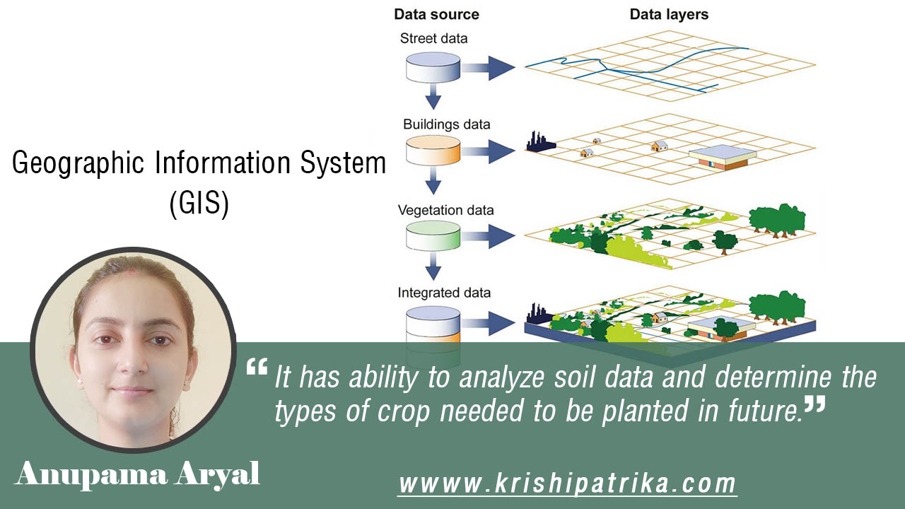
GIS assumes data as different layers to produce different visualizations such as thematic maps which on visualization reveals relationships, patterns, and trends. For instance, in the discipline of agriculture, individual and disparate layers can be produced from captured data on soil nutrients, elevation, moisture content, topography, and soil type. Then, these layers would be assembled to generate a map to show which factors to what extent influences the crop yield of a certain territory. Different tools within GIS allows to update, edit, view, query, analyze, manipulate, and reproduce maps as long as site-specific spatial data on different attributes of respective layers are provided. As opposed to paper maps, GIS can store and a large volume of data. Also, GIS together with GPS can greatly support farmers and growers in collecting relevant information to monitor and manage crops, yields, soil, vegetation, irrigation need, and potential threats to their fields. The precisely gathered data from fields followed by analysis in GIS could be used to guide future decisions for farms.
GIS technology has numerous advantages; however, challenges that come along are inevitable, especially for countries like Nepal. The underlying part of GIS is detailed field-level datasets and its database that has major roles in each step of creating agriculture maps. Various governmental and non-governmental organizations have their mandate or platform to upload and update their activities. However, the basic guidelines and principles for obtaining and storing geo-referenced spatial data related to agriculture are still lacking. Neither there is a repository system of agriculture-related datasets that allows users to obtain data when needed. Whilst, this is the requirement for applying implications of GIS in agriculture, it is unfortunate to find that even we don’t have enough non-spatial data to carry out certain kinds of trend or pattern study. So, until and unless we have well-managed data on various crops and their limiting factors, it is taxing to take any farm decisions with the help of GIS.
Besides, several factors can create obstacles in this way. Money is the major factor and quite a good amount of it is required to establish the foundation of agriculture digitization through GIS. It runs on a paid software like ArcGIS (though there are some existing open-source GIS softwares as well) which are expensive. Also, qualified surveyors, cartographers, analyst, and remote sensing experts are imperative for the overall relevant tasks. There could be other issues like data privacy, data sharing, capacity building, government policies, and acts that might come in between. Nevertheless, only by overcoming these hindrances can Nepalese experience the benefits of using GIS in farming practices. This process might take years to show outcomes but it will at least be instrumental to achieve a major milestone towards agriculture digitization in Nepal.
In a nutshell, GIS being a cross-cutting subject everyone needs to be aware of its importance and uses. It would create a huge impact on the research and further education of students as well, in case it is integrated as a course in bachelor’s level studies. To put into other words, the prior step lies in making technical students and people alert about the topic to develop a stimulus for the government to make policies in support of this digital start in the imminent future. GIS that has myriads of possible applications in farms obliquely has a positive influence upon the health of producers and consumers also. In a long run, this tool and related technologies might help minimize hunger throughout the nation with the rational utilization of available input resources in the cultivable land.